Saturday, January 30, 2016

Masada: Israel’s inspirational desert fortress

The Masada Plateau with the Snake Trail in the background -- Jews held off Roman legions for 3 years  (wikipedia)
MASADA, ISRAEL, January 30, 2016 At any given time, Israel is a troubling destination to visit. With the Middle East in a constant state of instability, making plans to visit the Holy Land to view the Biblical landmarks can be a challenge. Once there however, the desert country brings to life the history of some of the world’s great religions.

But there is another site in Israel that should be on every visitor’s must-see list. Masada is an ancient fortress situated on the crest of an isolated plateau overlooking the Dead Sea.

Masada's desolate ruins are impressive  (Taylor)
Located at the eastern edge of the Judean Desert, it was at Masada that a band of approximately 960 Jewish Sicarii rebels held off the Roman army for three years before being breached in 73 AD.

Like so much of the historical accuracy in the Holy Land, Masada is the subject of considerable architectural debate, but there can be no question about the existence of fortress itself, and therein lies much of its appeal.

Much of the controversy centers around the accounts of a 1st-century Jewish Roman historian named Josephus who is responsible for nearly all the written information about the story of Masada. The problem arises in the fact that most scholars regard Josephus as a less than reliable source for the details surrounding Masada.

Model of Herod the Great's three tiered palace which he never occupied  (Taylor)
Masada sits atop a 1,400-foot desert plateau that spreads over an area of 23 acres. Though never occupied by Herod the Great, he built a palatial villa there on three descending terraces at the northern end of the rock. Due to the angles, there are only partial views of the palace from above.

In 2001, Masada became a UNESCO World Heritage Site which can be reached by walking up the Snake Trail from the Dead Sea side, by the Roman Ramp Trail on the western side or by cable car.
According to Josephus, the Sicarii were an extremist group that split from a larger Jewish assembly known as the Zealots. They fled Jerusalem in 70 AD and settled at Masada after the massacre of a Roman garrison.

Water was a key factor in Masada's survival  (wikipedia)
The governor of Rome pursued the Sicarii and surrounded Masada but were stalled in their siege due to the strategic location of the fortress. Thanks to an ingeniously designed system of cisterns, the Jews often taunted their enemies by drenching them with fresh water in the severe desert heat of the region.

Eventually, the Romans began constructing a circumvallation wall and then a siege ramp against the western face of the plateau. Construction of the ramp was frequently stopped because the Jewish defenders were able to pelt the Romans from above with rocks.

In the end, the Romans succeeded by using Jewish captives to build the ramp. The Sicarii halted their stone bombardments in order to keep from killing their brethren.

After three long years, the Roman legion eventually breached Masada and captured the fortress. Upon their arrival however, the Romans discovered that most of the 960  inhabitants were dead and all the buildings except for the food storerooms had been burned. Only a handful of women and children survived
Partial view from above of Herod's palace at Masada as it exists today  (Taylor)
.

Josephus writes that the Jews of Masada either chose suicide or killed each other rather than suffer capture by the Romans.

Whether the Jews committed mass suicide remains a topic for conjecture. Other details that have proven to be either inaccurate or ommitted is also subject to scholarly debate.
The Snake Path was the primary access point to the Masada Fortress  (wikipedia)
What is known however, is that the elaborate system of channels that provided an ample water supply for the inhabitants does exist, as do the remnants of Herod’s northern villa. The siege did take place and the defenders were dead when the Romans entered the fortress.

A cable car is the fastest, easiest and most efficient way to reach Masada  (wikipedia)
As the debate continues, so does the symbolism of Masada in modern-day Israel. For Jews, Masada is a sign of unity against its adversaries. The site was regarded as so significant that the former Israeli military leader, Moshe Dayan, initiated the practice of holding swearing-in ceremonies for various units of the Israel Defense Forces (IDF) at Masada.

Over time the practice has been somewhat displaced, but Israel’s paratroopers still commemorate the Six Day War of 1967 at the Western Wall of Masada.
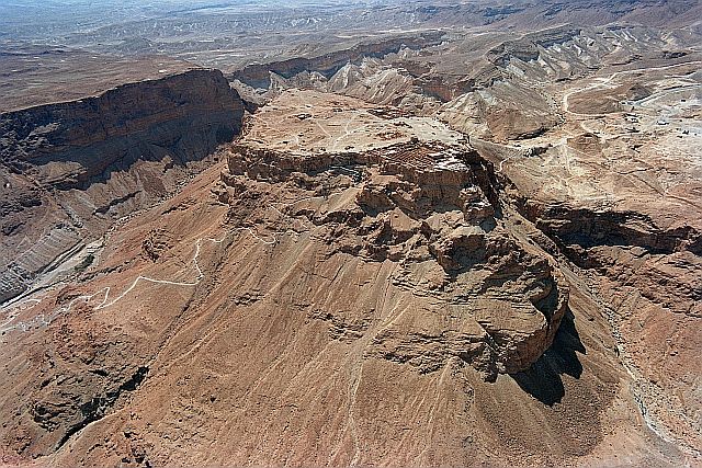
The Masada plateau is a symbol of determination and pride for Israel  (wikipedia)
Like so many places throughout the world, Masada is a site that much be visited in person to understand the full magnitude of its meaning.

For Americans Masada is, in its own way, much like the Battle of the Alamo. For Jews, given the historical chronology, they would likely tell us that the Alamo is more like Masada.

Like so many sites in the Holy Land, archaeology often creates more questions than answers. Whatever the truth may be about Masada however, cannot be diminished by a lack of information because the site speaks for itself.

This article first appeared in Communities Digital News

For more travel stories and exciting tour opportunities visit  Magellan Travel Club


Friday, January 15, 2016

Ancient basilica now open to the public in Rome

Entrance to the ancient basilica of Porta Maggiore discovered nearly 100 years ago  (wikipedia)
ROME, January 15, 2016 – For lovers of history, Italy’s capital is a living outdoor museum  Rome captures the imagination with its massive monuments like the Colossuem, the Forum, the Pantheon, the Vatican and, even, the Victor Emmanuelle Monument.

One of the everpresent problems with construction projects in cities like Rome, Athens and Jerusalem occurs when excavations begin and the builders bump into a new layer of ancient history.

Such was the case in 1917 in the outskirts of Rome during the construction of a railway line between Rome and Cassino. That’s when a secret pagan basilica was accidentally discovered following the cave in of an underground passage that unearthed a hidden chamber filled with stucco reliefs of gods, winged cherubs and pygmies.

Originally built by a wealthy Roman family, who belonged to a little-known called Neopythagoreanism, the subterranean basilica predates Chrisitianity. As might be deduced from the name, the cult was based upon the writings of the Greek philosophers Pythagoras and Plato.

Porta Maggiore is beneath a modern rail line  (wikipedia)
Situated directly beneath the rail line at street level, the 40-foot basilica is the only one of its kind in the world. Since its discovery nearly a century ago, Porta Maggiore, as it is now called, has been lovingly cleaned and preserved to the point where it can be viewed by the public, even though the restoration process continues.

Excavated from tufa volcanic rock, Porta Maggiore consists of three naves lined by six rock pillars and an apse. Carved reliefs of centaurs, griffins and satyrs adorn the arched walls along with depictions of classical lengendary Greek heroes like Achilles, Orpheus, Paris and Hercules.

According to the director of the site, Dr. Giovanna Bandini, “There were lots of cults worshipped at the time and the empire was in general fairly tolerant towards them. But this one was seen as a threat because it discounted the idea of the emperor as a divine mediator between mortals and the gods.”

In the first century A.D. getting the emperor angry was not a good thing to do. The Statilius family, which was responsible for the building, was accused of practicing black magic and other illicit rituals by Agrippina, the mother of Emperor Nero. A senate investigation took place and, though Titus Statilius Taurus continued to proclaim his innocence, his pleas fell upon deaf ears.

With no hope remaining, Titus Statilius Taurus committed suicide in 53 A.D.

Following Taurus’ death, the basilica fell into disrepair and was eventually sealed up by the Emperor Claudius before being forgotten about for centuries.

Tufa rock is relatively easy to excavate, which is also one of the reasons why Rome has an abundance of catacombs beneath the city.
Archways hearken to a time in history some 2,000 years ago  (wikipedia)
For the restoration process, scaffolding was built to allow access to the arched ceiling, which is covered with various stucco renderings. Some of the reliefs were decayed, but all things considered, restorers found the condition of the artwork to be in remarkably good condition.

Porta Maggiore is accessed by a door which hidden from the street by a mesh fence. The basilica itself is completely invisible to the outside world, but when trains rumble over- head, the illusion can be broken as a reminder that we still live in a contemporary world.
Artist's rendering of how Porta Maggiore might have looked in the 1st century (wikipedia)
A depiction of Medusa’s head guards the entrance with the lower parts of the walls painted in deep ox-blood red colors featuring wild birds and women dressed in togas.

Special care is taken to control temperature and humidity to preserve the artwork. The temperature must not rise above 64.4 degrees Fahrenheit while the humidity must constantly range between 87% and 92%.

Stucco begins to dry out below 87% humidity causing it to crack. Says Dr. Bandini, “This place is unique in the Roman world in terms of its architecture and design. It was a precursor to the basilicas built during the Christian era, centuries later.”

Visitors are now welcome, but space is limited. Arrangements for a tour can be made at www.coopculture.it or by calling +39 06 399 677 00

Rome is a timeline of history and civilization. So to say that Rome is a city in ruins is a compliment of the highest order.

This story first appeared in Communities Digital News

For more travel articles and information about tours in 2016, visit Magellan TravMagellan Travel Club


Saturday, December 26, 2015

The Bernina Express: The best rail journey in Switzerland

The Bernina Express travels over the Kreis Viaduct near Brusio -- An unusual outdoor spiral tunnel  (wikipedia)
SWITZERLAND, December 26, 2015 – Switzerland has five classic rail journeys and each is breathtaking in its own way. But if you have to pick only one, choose the Bernina Express.

It may not be Switzerland’s longest, or most famous, train ride, but it is arguably the best. 

Bernina Express operates year round  (wikipedia)
Not only does the route incorporate some of the most spectacular sections of the famed Glacier Express, it also features alpine lakes at the crest of the world,  dynamic glaciers and panoramic vistas of rolling countryside before reaching its final destination in Tirano, Italy.

Even National Geographic rates the Bernina Express as the second best rail journey in Europe.  The first, also in Switzerland, is The Chocolate Train. 

Bernina Express travelers begin from either Davos, St. Moritz or Chur.  Each village offers something different, so the starting point is really a matter of personal preference. 

Chur, with its delightful old town, is a gateway to the alpine ski resort of Arosa. 

At just over 5,000 feet, Davos has the distinction of being the highest city in Europe, and it is a haven for culture lovers as well as sports enthusiasts.
 
Jet-setting St. Moritz, with its series of three alpine lakes, has long been a favorite destination for the internationally rich and famous. 
Panoramic windows heighten the experience of the Bernina Express  (wikipedia)
The four-hour, 38-mile rail journey follows a winding mountainous path over 196 bridges and through 55 tunnels over the Bernina Pass which reaches its highest point at more than 7,300 feet.  Two railways, the Albula Line and the Bernina Line, combine to form the route.  A unification that led UNESCO to jointly declare them a World Heritage Site in 2008.

Completed in 1904, the Albula Line took six years to build.  The Bernina Line followed in 1910, but the railroads operated independently until 1940 when the Rhaetian Railway took over and merged the two.

Any time of year is good on the Bernina (swissrailways.com)
The brightly colored red coaches feature arches of glass that provide a 360-degree panoramic view of land, water and sky.  During summer, some trains even operate with a few open-air cars as well as the traditional enclosed rolling stock.

The combination Landwasser Viaduct/Tunnel is a highlight of both the Bernina and Glacier Express excursions.  From the viaduct, where five pillars tower more than 200 feet above the Landwasser River, the 446-foot curved track offers passengers a clear view of the train as it enters or departs the tunnel. 

The 706-foot tunnel completes the architectural masterpiece by boring through seemingly insurpassable rock before opening upon the dramatic gorge and bridge across the river.

Shortly after the viaduct, the train reaches Filisur before continuing through the first of several spiral tunnels.  The rails sing as the cherry-colored line of coaches moves through a lush valley en route to a change in elevation of about 1,300-feet in just over 3-miles.


Spirals eliminate the need for rack-and-pinion infrastructure and passengers are the beneficiary.  The serpentine course twists and turns through towering woodlands past cascading waterfalls and rushing streams while climbing toward mountains of everlasting snow.
Crossing the Landwasser Viaduct is a highlight of the Bernina Express experience  (wikipedia)
Outside Pontresina the journey heads for the Bernina Pass where the tracks make a dramatic turn beside the  Morteratsch Glacier.  Lord Byron once described glaciers as “frozen hurricanes” and, at this place, it’s as though some omnipotent hand designed the terrain purely for rail visitors to observe all of it’s magnificent splendor. From here you can view the Piz Bernina, the highest summit in the Eastern Alps at nearly 7,000 feet. 

In English “piz” means “peak”, which comes from Romansch, the least used of Switzerland’s four languages.

Chur is one of three gateways  (wikipedia)
Before long, the Bernina Express discards its forested surroundings by yielding to a moonscape of stark, intolerant terrain.  Jagged, barren outcroppings of snow-clad rock hover over three glacial lakes, each distinguished by a different color.  Here, at the rooftop of Europe, the watershed divides the flow of rivers toward the North Sea and the Mediterranean.

Once over the Alps, the train descends into another vast carpet of green where rural tableaus nestle between protective mountains that lead toward Brusio and its spiral viaduct.  The uniqueness of this rarest of rail travel experiences lies in the fact that the track is completely exposed, allowing passengers to witness the logistical achievement of the design for themselves.  The train travels over, around and beneath its own pathway as the coiled ribbon of steel guides the express into Italy

At the top of the world, Bernina Express passes three lakes with different colors. This is the White Lake. (wikipedia)
Before terminating in Tirano, rail travelers and motorists discover several places along the route where it almost seems possible to reach out and shake hands with each other, and in a couple of tiny villages, the train has barely enough room to pass between buildings on either side of the road.
Just another day in paradise aboard the Bernina Express  (wikipedia)
At Tirano, the Bernina Express links with Swiss Postal Bus service which journeys along the Italian shores of Lake Como before arriving back in Switzerland at Lugano.  For Swiss Rail Pass holders, the only thing required is making a reservation and showing your pass.

While glaciers and palm trees may seem incongruous, the magic of the Swiss Travel System makes it possible.  All you have to do is “train” yourself.


The Bernina Express is proof positive that “one good turn deserves another.” 

This article first published in Communities Digital News 

Read more travel stories and discover great tours at:  Magellan Travel Club

Saturday, December 19, 2015

Discovering the small villages of France on the Web

A quaint quiet street in Flavigny-sur-Ozerain where much of the movie Chocolat was filmed  (wikipedia)
FRANCE, December 19, 2015 – Moviegoers who saw the 2000 film Chocolat may recall the tiny fictional village of Lansquenet-sous-Tannes where the story takes place. In fact, two real French villages were used Flavigny-sur-Ozerain in and Beynac-et-Cazenac on the Dordogne River in Dordogne.

Both places are members of an organization called “The Most Beautiful Villages in France.”

Outskirts of Peyre, France (wikipedia)
Travelers will be thrilled to discover that there are more than 150 other “undiscovered” villages throughout France that are now part of an internet site called Les Plus Beaux Villages de France.

This site traces its roots to 1981 when Charles Ceyrac, the mayor of Collonges-la-Rouge, found a book published by Reader’s Digest which had the same title as the current name of his organization, Les Plus Beaux Villages de France.

Ceyrac had long been an advocate of promoting tourism to exceptional villages throughout France that were largely unknown, yet possessed a prominent cultural heritage. With inexhaustible energy and a keen desire to protect the heritage of these communities, Ceyrac passionately undertook the task of forming an association with rigid standards to create greater awareness for visitors.

Several categories for inclusion were established ranging from history to art, handicrafts, culinary excellence, romantic environment, wellness and nature.

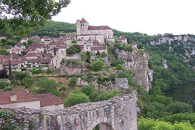
Saint Cirq Lapopie nestles behind its ancient city walls  (wikipedia)
By March of 1982, an organization of 66 mayors had united with Ceyrac to establish a method of preserving the legacy of each town. Its purpose was “to avoid certain pitfalls such as villages turning into soulless museums or, on the contrary, ‘theme parks.’ Our well-reasoned and passionate ambition is to reconcile villages with the future and to restore life around the fountain or in the square shaded by hundred-year-old lime and plane trees.”

In an effort to regulate a high level of quality so that visitors would be guaranteed to enjoy the type of traveling experience they were seeking, Les Plus Beaux Villages de France follows a strict set of guidelines during its selection process.

Membership is granted only after a community has completed four phases of application.
Entrance to the village of Flavigny-sur-Ozerain (wikipedia)

 Initially a village must meet three basic requirements: the population must not exceed 2,000 people, it must have at least two protected sites or monuments in the area, and it must show written proof that there is majority support from the town council.

Once approved, an on-site evaluation is conducted between a member of the association and the mayor of the village. Prior to the “tour” of the town, the mayor, and any associates he chooses, are interviewed and are requested to present required documents for evaluation along with any support materials.

The association then follows an appraisal chart consisting of 27 criteria that rate the village according to the various categories necessary to participate.
Half timbered houses of Le Bec Hellouin in Normandy  (wikipedia)
Phase three consists of a decision handed down by the Quality Committee which has complete authority in accepting or rejecting an application. The Quality Committee meets twice each year, and it has the option of making four rulings ranging from immediate recognition as a participating member to total rejection.

If approved, the final step is signing an official charter. Once granted, the village may then promote its new designation to inhabitants, local authorities and the media as being officially regarded as one of the Most Beautiful Villages of France.
Beynac-et-Cazenac rises above the Dordogne River in France  (wikipedia)
Today there are more than 157 villages in 21 regions of the country.

“Discovering France” has never been easier or more enjoyable thanks to Les Plus Beaux Villages de France.

For more stories and tour itineraries, visit:  www.MagellanTravelClub.comwww.MagellanTravelClub.com


Saturday, December 12, 2015

For winter fun in the sun, try the Turks & Caicos


Miles of white sand beach stretch along the shores of Grace Bay in the Turks & Caicos  (Taylor)
TURKS & CAICOS, December 12, 2015 – Christopher Columbus discovered the Turks & Caicos from the sea in 1492. Nearly 500 years later astronaut John Glenn rediscovered them from space, and they haven't been the same since. 

The main pool at the Sands at Grace Bay  (Taylor)
Six years later the airport opened in the capital city of Providenciales, or Provo as it is called by locals, and large scale international tourism was on the horizon.

Despite the influx of travelers however, the chain of 41 islands has been extremely sensitive to over-development, choosing instead to upgrade infrastructure while maintaining its pre-Glenn ambiance. It’s a recipe that has made them one of the most desirable destinations in the Caribbean.

So careful have the residents been about protecting their “pristine” image that the main road was paved less than ten years ago and only now is the airport in the process of upgrading to accommodate the increase of international travelers.
Water sports, especially snorkeling for conch, are favorite pastimes in the Turks & Caicos  (Taylor)
There are two sets of islands in the archipelago, of which roughly 25% are inhabited. The Turks derive their name from the indigenous Turk’s head cactus, while Caicos comes from the Lucayan term caya hica meaning “string of islands.” Before Christopher Columbus arrived in 1492 the Lucayan and the Taino Indians comprised the native population.

Rum punch and conch salad are staples  (Taylor)
The Turks make up the northern cluster of islands, while the Caicos are to the south. Most of the tourist activity these days centers around Grace Bay where luxury hotels offer all the amenities a visitor desires while retaining an atmosphere of seclusion and a respect for the environment.

Activities include kayaking, snorkeling, scuba diving, nature walks, parasailing, paddle-boarding and, of course, golf. Boasting the third largest coral reef in the world, combined with an abundance of conch, it’s little wonder that water activities are among the most popular.

Reef Peepers, one of several popular outfitters in the islands, offers a variety of excursions. Half-day snorkeling programs include snorkeling, gear, searching for conch, a visit to Half Moon Bay, lunch and drinks. You can also try TI Reef Adventure on Grand Turk for snorkeling sessions, adventures with stingrays, and deep sea fishing.
A rock iguana greets guests at his home on Iguana Island  (Taylor)
Half Moon Bay, also known as Iguana Island, is a favorite outing because it is the home of the rock iguana, the smallest creature of its type in the Caribbean.

As might be expected in an area so linked to the sea, there is a passion for shellfish, especially conch. It is virtually impossible to go anywhere and not find conch on a restaurant menu in one form or another. In fact, the Caicos Conch farm is the only commercial conch farm in the world.

Da Conch Shack is an island favorite  (Taylor)
Arguably the favorite hangout on Provo is Da Conch Shack, which harvests its own conch for its signature white meat delicacies of conch fritters, conch salad and scorched conch. You can even watch as they pull lunch or dinner directly from the water before preparing it within minutes. You would be hard pressed to find food fresher than that.

Jerk chicken is also a popular island dish. Smokey’s has the reputation for the best jerk chicken, plus you can play a round or two of miniature golf before or after your meal.
The Sands at Grace Bay is a metaphor for relaxation, comfort and luxury  (Taylor)
The islands feature a wide range of accommodations catering to any budget. The more upscale properties can be pricey, as with any resort, but they are not extravagant by luxury standards. The Sands at Grace Bay features multiple swimming pools, a small spa, spacious rooms, superb dining for breakfast, lunch and dinner and a twelve mile stretch of white sand beach to boot.

Rooms at the Sands are extra spacious  (Taylor)
Situated just eighty minutes by air from Miami, the Turks & Caicos are easy to reach, especially from the east coast of the U.S. Little wonder 70% of the visitors come from the United States and another 20% arrive from Canada.

Driving can be tricky until you get accustomed to using the left side of the road, but the ability to use U.S. dollars and American electrical outlets quickly compensates for the driving adjustments.

Off-season travel is increasing in popularity for many people, but when it comes to the Caribbean, off-season is really a misnomer. In a land of eternal summer and sunshine, it really doesn’t matter when you visit. As a result, the so-called off-season in the Turks provides the same wonderful weather plus a reduction in price.

Days end in the TCI always has the promise a bold new tomorrow  (Taylor)
Today, Turks & Caicos stands on the threshold of an exciting future boasting the fastest growing economy in the Caribbean coupled with strictly controlled development to protect the islands.


Island life as it used to be combined with luxury and comfort is the best of two worlds, and you can find it in the Turks & Caicos.

The article appeared first in Communities Digital News
For more travel stories and great tour opportunities visit  Magellan Travel Club

Friday, December 4, 2015

Finland: Where creativity abounds with “designs” on the future

The Sibelius Monument in Helsinki looks like an irregular series of organ pipes  (wikipedia)
FINLAND. November 7, 2015 – Admittedly this story is better suited for summer travel unless you thrive on outdoor winter activities. That said, Finland celebrates the 150th anniversary of the birth of national composer, Jean Sibelius, on December 8th. With that in mind, here are three great day trips you can do in Finland from the capital city of Helsinki.

1 – Iittala & Nuutajärvi (Finnish Glass) – Visitors to Finland are often surprised at the superb ceramics and design that is a national characteristic of the country. Nowhere is contemporary creativity better displayed in Finland than in the glass district.


Glass blowing demonstrations are popular  (wikipedia)
Nuutajärvi Glass, founded in 1793, is the oldest functioning glass factory in Finland. The factory site itself is one of the best preserved milieus in the country. Built in Neo-renaissance architectural style the bell tower dates to the 18th century while the manor house, constructed in 1822, remains active nearly 200 years later.

Today, one of Nuutajärvi’s most popular collections is Birds by Toikka established in 1962 by Oiva Toikka who remains one of the greatest names in the history of Finnish glass.  

Nearby, another glassworks founded in 1881, Iittala has  expanded into other areas of design such as ceramics and metal which today includes tableware and cookware. Over the decades, thanks to an all-star group of designers, Iittala has built an international reputation for elegance and timeless design.

Commemorative Alvar Aalto stamp  (wikipedia)
Among the most famous artists were Oiva Toikka and Alvar Aalto who created his iconic Savoy Vase, now affectionately known as the Aalto Vase, in 1936.

For travelers, not only are the glass products unique souvenirs, but the glass blowing process itself is worth the visit. Here master craftsman breathe crystalline beauty from red-hot molten glass into incomparable glassware.

From the Aalto Vase to the exquisite architecture of Finlandia Hall, the white marble congress center in Helsinki, nothing better emphasizes the range of Finnish creativity. Completed in 1971, every detail of the building was designed by Aalto.
Stunning white marble facade of Finlandia Hall, designed entirely by Alvar Aalto  (wikipedia)
Such diversity makes Finnish design and craftsmanship “crystal clear.”

2 – HvittraskSpeaking of building design, Hvittrask may just represent the greatest collection of architectural brilliance in history.
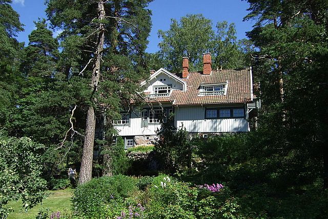
Architect's home and studio at Hvittrask just outside of Helsinki  (wikipedia)
Located just 19 miles west of Helsinki, Hvittrask was originally designed to be a studio home for associates of a Finnish architectural company. It later became the private residence of Eliel Saarinen, Herman Gesellius and Armas Lindgren. Constructed of logs and natural stone, the studio was created to provide the ultimate working environment for architectural innovation. Among the innovative studio designs was a huge slanted skylight that maximized the natural light in the forest to its fullest advantage.

Hvittrask translates in English to mean “White Lake” deriving its name from the small lake at the end of a wooded path leading from the house.

Eliel Saarinen lived at Hvittrask  (wikipedia)
Hvittrask was not without scandal, however, which makes the site all the more intriguing. During the time of their residence, Saarinen fell in love with Gesellius’ younger sister Louise, a sculptor in Helsinki. Following his divorce from his first wife, Mathilde in 1904, Saarinen married Louise, thus making it possible for Gesellius to marry Mathilde. One can only imagine what holiday gatherings were like at Hvittrask.

The site was also the boyhood home of Eero Saarinen, the son of Eliel and Louise.  Eero primarily made his reputation in the United States designing monuments such as the Gateway Arch in St. Louis.

During its heyday, Hvittrask was regularly visited by artist Axel Gallen-Kallela, writer/dramatist Maksim Gorki and composer Jean Sibelius.

3 – AinolaTravelers to Finland immediately recognize the Finnish passion for the outdoors and Mother Nature. Ainola, which means “Aino’s place” in honor of Jean Sibelius’ wife, is the ideal synonym for that  zeal.


Jean Sibelius' home overlooking a lake at Ainola in Finland  (wikipedia)
Situated on the shores of Lake Tuusulaniärvi in forested surroundings, Ainola was the family home from 1904 to 1972. Sibelius required only two things from architect Lars Sonck; a lakefront view and a green fireplace in the dining room.

Sibelius portrait  (wikipedia)
The site was chosen for its solitude which Sibelius demanded for his work. Don't expect to hear the music of Finland’s national composer during a tour, Ainola remains totally silent out of respect for Sibelius’ need to concentrate.

So intense was Sibelius for quiet that water pipes were not installed in the house while he was alive because he could not deal with any distractions during construction.

Though isolated, the passion for nature attracted other Finnish artists to the area providing an active social circle for Sibelius and his family when he was not concentrating on his work.

Sibelius died in 1957 and is buried in a garden at Ainola. Today the home is open for visitors from May to September.
Ainola is now a seasonal museum open to the public from May to September  (wikipedia)
So you see, traveling to Scandinavia can be a rewarding exercise in all disciplines of creativity, and here are three examples of day trips to enjoy from start to Finnish.


Article first published in Communities Digital News

For more travel information, stories and tours visit  Magellan Travel Club